Why did Morro Bay officials select the site of the water recycling plant?
October 1, 2021
Writer’s Note: This is part five of a story, told in installments, about the corruption involved in Morro Bay’s water reclamation facility. Part one is about Morro Bay City Council’s bait-and-switch.
OPINION by CYNTHIA HAWLEY
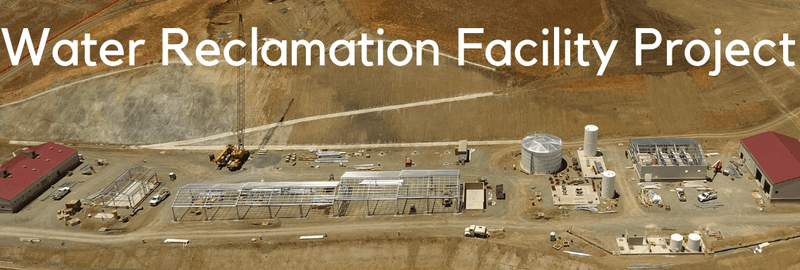
Have you wondered why the Morro Bay City Council chose the South Bay Boulevard site for the Water Reclamation Facility?
Why this site when it did not provide any public benefit that other sites didn’t offer? The council members knew that it added at least $26,000,000 to the lowest cost option and that it required digging up Quintana Road. And they knew it would mean decades of pumping all of Morro Bay’s raw sewage almost three miles inland and uphill.
In 2017, the city council convened a peer review panel of wastewater professionals who informed council members that the best way to reduce project costs was to not use the South Bay Boulevard site. The panel said that “the biggest contributor to cost at the South Bay Boulevard site is the site itself. Pipeline and earthwork costs there are very high.”
But why this site when the entire project site is designated by San Luis Obispo County as a Geologic Study Area (GSA)? According to the county’s Estero Area Plan and land use ordinance GSA means that the ground is subject to high landslide risk. The Geologic Hazard Map in the project Environment Impact Report (EIR) also shows that the whole project site is designated a “landslide risk”.
The city’s own geotechnical report describes the soil at the project site as including “… landslide deposits …” and as “…commonly associated with … slope instability and landsliding,”
And — especially in light of these known hazardous conditions — why this site when it is on the bank of a stream that flows directly within about a mile into the Morro Bay National Estuary? Stormwater carrying soil from a landslide could cause catastrophic harms to the estuary.
Then there are the facts that there is no use permit for the project and the estuary was illegally excluded from the project EIR. The engineering plans were never permitted and they were developed without required data and consideration of impacts the project might have on the estuary, it’s habitats, and species.
Since the site was graded two landslides have let loose an estimated 32,000 cubic yards of earth above the construction site. This earth is being piled on the same hill above the site and above the stream. Reported costs so far are $1,105,313. Who is paying for this? Ratepayers.
So, according to the record, selection of this site didn’t have anything to do with benefiting the people who are paying for it, protecting the public’s money, or protecting Morro Bay’s irreplaceable estuary.
The record shows that the die was cast in 2016 when purchase of the site — 30 acres of a 400 acre parcel of agricultural land on the city’s border — was explicitly for the purpose of making the remaining 370 acres developable and getting ratepayers to pay for it. Here’s how they did it.
The public record of these actions begins at their Oct, 11, 2016 meeting when the council members approved an agreement, a memorandum of understanding (MOU), with the owner of the 400 acre parcel. The MOU was cast as an option to buy about 30 acres of the land for the sewage treatment facility — an uncalled-for act since, as noted in the staff report, the city could use eminent domain to buy the land.
After a determined search, Morro Bay resident Nancy Bast found this MOU. She discovered that the terms within it included more than the unneeded option-to-buy. It included the city council’s agreement to provide, among other things:
1. The processing and costs of a proposal to the Local Agency Formation Commission (LAFCO) to modify the city’s sphere of influence to include the remainder parcel of approximately 370 acres,
2. the development and maintenance of an access and utility easement on the 370 acre parcel,
3. the water reclaimed from the treatment plant for agricultural use on the remainder parcel if the city decides to use it for agriculture. See for yourself in the MOU.
These acts are prohibited gifts of public resources and money and major land use decisions that require general plan amendments and opportunities for public participation at noticed public meetings.
But the council members proceeded to actively hide the existence of these gifts and land use changes.
When the MOU was approved in Oct. 2016, the gifts and land use changes were not disclosed in the agenda notice or the staff report that recommended the approval, and the meeting minutes were falsified to omit the existence of them.
Then, over two years after the promises were made in the MOU, the modification of the city’s sphere of influence to include the 370 acre parcel of private property resurfaced at the city council’s Jan. 22, 2019 meeting as an element of the Water Reclamation Facility. Here’s how that was done with the public notice of what was to occur.
According to city staff, “Monthly review of the status of and actions regarding the water reclamation program including: 1. Update on the Water Reclamation Facility design/build process; 2. Adoption of Resolution No. 08-19, authorizing the annexation and sphere of influence change application for the South Bay Boulevard site… .”
The recommended action to include the sphere of influence change as part of the Water Reclamation Facility was to “approve Resolution 08-19 authorizing staff to complete and submit an application to LAFCO for a sphere of influence designation for the approximately 400-acre Tri W, Inc. property near South Bay Boulevard and annexation of 27.6 acres of that property (Assessor’s Parcel Number 073-101-017).” All the council members except Heller voted to approve it.
However, according to the council’s June 25, 2019 staff report, LAFCO staff told the city “to file two separate applications for the sphere of influence and annexation actions being sought.”
But despite the separate applications, the private property sphere of influence amendment was still processed — and paid for by ratepayers — as part of the wastewater treatment project.
At the June 25, 2019 meeting, the private property sphere of influence Resolution 55-19 and the public property annexation Resolution 54-19 were merged as a single public works item, within a single staff report and a single recommendation by the public works director and the Water Reclamation Facility manager for approval with “no alternatives recommended.” See it for yourself.
With no mention of a public purpose or benefit (because there wasn’t one), Resolution 55-19 states that “pursuant to the MOU, the city is processing a proposal for the approximately 370-acre remainder of the property to be included in the city’s sphere of influence.”
The staff report that recommended approval of Resolution 55-19 gave false information that the sphere of influence amendment would result in “no additional fiscal impact” and did not disclose how much it would cost. But it did disclose where the money was coming from to pay for it, the “city’s fiscal year 2018-19 budget for the Water Reclamation Facility project,” that is, monthly water and sewer rate payments.
Later in 2019, the city council made good on the promise and used public works staff time to generate a 43-page proposal to LAFCO to expand the city’s sphere of influence to include the 370 acres and submitted the proposal along with a check for $4,500 of ratepayer money from the Water Reclamation Facility project fund.
In this proposal, the public works department admits that the purpose of the MOU was to provide a vehicle “to modify its sphere of influence to include the remainder parcel” where there was no public benefit to justify it. The staff report goes on to admit that:
The key provision of the MOU is Section 8, which states: ‘”City will process an annexation proposal for the property, as well as a proposal to modify its sphere of influence to include the remainder parcel,” and the remainder parcel refers to balance of the 396-acre property (APN 073-101-017).” See page 1 of the proposal to LAFCO.
What was aillegally hidden from the public when the MOU was approved in 2016 as an “option to buy” was later revealed to be the “key provision” of the memorandum of agreement to be funded with Water Reclamation Facility ratepayer money. The purpose of the MOU was to take actions toward making the property developable.
Along with being an unauthorized use of public funds for a private purpose (misappropriation under Penal Code section 424), under Proposition 218 the California Constitution states, “Revenues derived from the fee or charge shall not be used for any purpose other than that for which the fee or charge was imposed.” And Government Code section 8314 prohibits local officers from using public resources for anything that is not authorized by law.
At their July 14, 2020 meeting the council members did a similar thing in relation to right of entry easements on other properties adjacent to the Water Reclamation Facility site. The council members brought the parcels into the project by deciding to create easements on them for additional access to the facility. Since there is no use permit to be publicly amended the project is changed without public oversight and participation.
Then, just like with the MOU, using an unrelated Right-of-Entry Agreement as the vehicle, the city council agreed “to cooperate with the property owners in processing and considering a zone change application from the existing suburban residential/planned development overlay to a more dense zoning, including, but not limited to, multiple-family residential for the approximately 44 acre parcel.”
The record shows that the council members chose this site — knowing that it increased the costs by tens of millions of dollars to bury sewer pipes under Quintana Road, meant risking landslides on unstable land and the costs of dealing with landslides, and meant threats of possible catastrophic harms to the National Estuary — as a way to steer Morro Bay’s future toward expanded urban development without public participation.


The comments below represent the opinion of the writer and do not represent the views or policies of CalCoastNews.com. Please address the Policies, events and arguments, not the person. Constructive debate is good; mockery, taunting, and name calling is not. Comment Guidelines