Surf, coastal flood and wind advisories as storms move towards SLO County
January 9, 2024
By KAREN VELIE
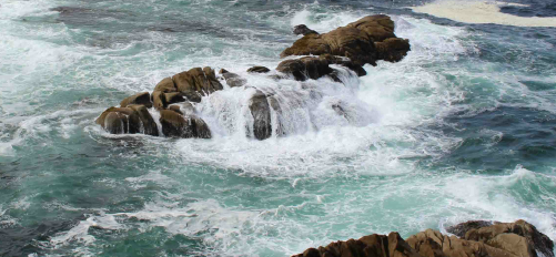
Two storms are headed to San Luis Obispo County, one is slated to arrive on Tuesday night while the other moves in on Wednesday. The storms are are forecast to bring breaking waves of up to 17 feet with dangerous rip currents, according to the National Weather Service.
Rip currents can pull swimmers and surfers out to sea, creating an increased risk of drowning. Large breaking waves can wash people off beaches and rocks, and capsize small boats near shore.
A high-surf advisory is in effect for coastal areas of SLO County until 9 a.m. on Friday. A coastal flood advisory is slated for Wednesday at 3 a.m. until Friday at 12 p.m.
“Flooding of sea water is likely, around the time of high tide, over vulnerable low-lying coastal areas such as parking lots, beaches, and walkways,” according to the National Weather Service. “Significant damage to roads or structures is not expected.”
Forecasters predict high tide on Wednesday at 6.8 feet at 8:10 a.m. and 6.9 feet at 8:55 a.m. on Thursday.
Northwest winds of 15 to 25 mph with gusts up to 40 to 50 mph are expected. A wind advisory, for Central Coast beaches and SLO County mountain areas, starts at 4 p.m. on Wednesday and ends at noon on Thursday
“Gusty winds will blow around unsecured objects and make driving difficult, especially for high profile vehicles,” according to the National Weather Service. “Tree limbs could be blown down and a few power outages may result. Use extra caution when driving, especially if operating a high profile vehicle. Secure outdoor objects.”


The comments below represent the opinion of the writer and do not represent the views or policies of CalCoastNews.com. Please address the Policies, events and arguments, not the person. Constructive debate is good; mockery, taunting, and name calling is not. Comment Guidelines