Plane crash victims’ questionable pasts

August 9, 2015

Santa Barbara plane crashBy KAREN VELIE

Exclusive: The two men identified in a plane crash in the backcountry of Santa Barbara have been identified as a San Diego pilot and a businessman, both of whom have questionable backgrounds.

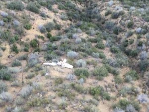
The pilot, David Keith Martz, 58, and his passenger, 56-year-old Birger Greg Bacino died in the Thursday night crash. Officials said Bacino had hired Martz, a commercial pilot, to fly him to a business meeting in San Luis Obispo in a plane rented in San Diego.

Since 1986, Martz license has been revoked or suspended four times, once for having sex while piloting a helicopter. Martz made headlines in 2009 for filming porn star Puma Swede performing oral sex on him as they flew over San Diego.

In 2010, Bacino plead guilty to workers compensation fraud, according to the Claims Journal.
According to court records, Bacino had been a successful trial lawyer when he decided to change occupations and became a real estate developer heavily involved in health care management. After several years, Bacino plead guilty to a criminal charge of capping (capping is illegal ambulance chasing).

In 2014, La Jolla Bank contested Bacino’s bankruptcy filing seeking relief of more than $14 million owed to the bank. The bank claimed Bacino’s bankruptcy filing should not result in discharging his debt because of Bacino’s false statements or fraud, according to a 2014 court decision in which a judge ruled in favor of the bank.

In 2015, Bacino started Ftlb LLC, a medical management company.

Last week, Martz flew Bacino to San Luis Obispo for a business meeting. On their return flight, Martz left the San Luis Obispo airport at about 9 p.m. and reported engine trouble shortly before their plane crashed in the Los Padres National Forest.


Loading...
17 Comments
Inline Feedbacks
View all comments

Just stumbled on this website and wanted to clear up a few things. This aircraft NEVER talked to Santa Barbara Approach. It came from Los Angeles Center and was handed off to Mugu Approach. Within 2 minutes after checking in with Mugu the pilot said “I HAVE A PROBLEM UP HERE”. He stated that his engine blew, he was getting oil on his windshield and smoke in the cockpit. He was given the distance to Santa Paula airport which is unlighted and Camarillo airport, but he said he couldn’t make it to either one. He was given the distance to Santa Barbara airport and asked for radar vectors there. The aircraft was on a VFR flight plan. The flight progress strip did state he departed from LPC Lompoc. Where he departed from truly is unknown to me. The pilot did check in with the actual tail number from the plane. He was not trying to be shady. Someone typed in the wrong callsign by accident. May this man and his passenger Rest In Peace.


Flight Aware presented the flight activity for N5378F as departing KLPC (Lompoc) to KCRQ (Palomar) as stated by others. The flight track is as others stated, and it appears that the plane was not on an instrument flight plan. That assumption is based upon the, albeit brief, cruising altitude, which was a visual flight rules altitude.


I cannot explain why FlightAware shows Lompoc as the departure airport other than an assumption that when the pilot contacted Air Traffic Control in Santa Barbara (SBA) for traffic advisories while near the Oceano Airport the controller simply picked an identifier close to where he pickup of the plane on radar. Normally ATC will use SC5 as the popup location, meaning, Unknown, as is shown on the real N number flight tracking for June 2nd for a flight to Big Bear.


With the track beginning near Oceano it makes sense that the plane took off from SLO, not Lompoc, and climbed southeast wherein contact was made with SBA Approach at 4000 feet and climbing southeast.


The aircraft number showing in FlightAware is N5378F, which is also shown as being owned by “unknown”. It’s a bogus registration number. The real registration for the crash aircraft is N5738F. Simple transpose of numbers I suspect. Although, I suppose it is possible that the pilot gave SBA controllers the bogus number deliberately, but I would doubt that. Why would he do that? So nobody back home would know where he was or had been? If that was the plan, why call SBA for advisories at all. Blast on home without talking to anybody, as it appears he did on the flight to SBP.


If he had been the owner of that plane, I would say he deliberately provided a bogus number. However, this was a rental, it was dark, and older C-182’s typically do not have the best of instrument panel lighting and N numbers can become difficult to read at night. It is highly possible that he transposed the number for his call in to SBA approach control.


I am a little surprised that nobody has come forward to state that they met with these people in SLO, or perhaps nobody has asked yet asked. NTSB will likely do so.


So, for those that wish to drag the entertaining past of these two people into this, you will just have to wait. But feel free to tie them to whatever corruption, sex, lies, politicians and whatever you like on these pages. It is entertaining, but totally nonsense.


They are dead, seriously! Is there any point in mulling over their nefarious behaviors? May they rest in peace and their loved ones be allowed to grieve and mourn without further tarnishing.


This is all rather strange. Why would they lie about their flight plan? With such a shady past, is it possible that they wanted to create an alibi by indicating that they weren’t someplace that they really were at a particular time? What did they do here in SLO and why would they want to indicate that they were actually in Lompoc? Just wondering…….


Cindy… just wondering, is there more to this article that I missed?

Where does it say in the article that they were in Lompoc?

Where does it say that they filed a flight plan?


by the way, being a pilot for over 25 years I can say that I’ve known many pilots that had/tried some sexual adventure at some time in their piloting experience…..


Abe, check Noozhawk(dot)com for the whole story. Every agency that rubber stamped the AP breaking story got it wrong. KSBY is the only local news agency that has NOT corrected their story to state that the flight departed from SLO and not Lompoc. On the flightaware(dot)com home page, search for flights from KLPC to KCRQ (Polomar) – it is the C182 marked N5378F. If you search from KSBP to KCRQ last Thurs, you’ll find no entries for a C182. On their FAQ webpage the question: “What, exactly, is represented by the flight route line on a FlightAware map?” is answered: “The solid line displayed on a FlightAware map is a connected series of points between every position report received for that aircraft. Generally, we receive a position every 15-60 seconds. The dashed line is the planned route of flight per air traffic control. Often times, a flight will deviate from the planned route due to weather, shortcuts, traffic, or other operational factors. As you will see, if that’s not a deviation from planned route/reported route to actual flight path, I don’t know what is. The flight path clearly shows they went down about 10 miles N of Jamison Lake.


The confusion appears to stem from a misunderstanding of how flight aware works.


Some basics general aviation facts….


~~Unless the flight has to be flown in IFR conditions ( it is raining, foggy, etc.) the pilot does not have to file any flight plans with the FAA. Very similar to driving a car, you can take off and go where ever/when ever you want to go without asking anyone’s (FAA) permission (except around the largest airports such as LAX, SFO).


~~After you take off and are on your way, you are not required to be in contact with any controller until you want to land at an airport. If you want to be in contact great, but it is not required.


~~Flight aware gets its information from controller if and when the pilot initiates contact or if the pilot files a flight plan.


In this case, it seems that the pilot originally filed a flight plan expecting to go from Lompoc To Polomar ( the dashed lines). Instead, he flew out of San Luis Obispo and contacted the controller shortly there after and that flight information is depicted as solid green.


There is no reason to suspect anything nefarious or illegal about the flight..period..


Thanks for the clarification Abe. So I guess the details on how he got from Lompoc or wherever to SLO would be in his log book then? Also, does the initial contact with ATC associate the flight path (the solid line) with the aircraft number? And since the solid line follows the recorded Lat, Lon and Alt (el?) in the associated chart, does that mean he was being actively tracked by radar? I noticed in the chart that he had negative alt (el?) as though he dipped below the terrain and lost radar contact as he looped back before being picked up again one last time before the records terminated. Just curious. This stuff is fascinating. Kinda like MH370


you are correct BE… when a pilot calls up ATC and asks for flight following, the pilot gives the planes location, it’s N number and type of aircraft. ATC searches it’s radar screen at the given location and finds the aircraft. At that time, ATC puts the information into the system and starts the tracking, which is shown as solid green.


I am not a pilot. I am however a licensed driver. Would my license be suspended or revoked for the same offense? I’m sure the statute of limitations has expired but I would like to know for, hopefully, future reference.


there was no “offense”..


Sounds like maybe they may have initiated Hill to the Mile High Club.


Probably meeting with Adam hill.


If not Hill, maybe developers Ryan Petetit and John Belsher and then they could make the contributions to Jan Marx and Adam Hill’s campaign. Funny how all the scum circle the wagons together!


At least this county will not have two more corrupt losers to deal with! because we all know we have enough!


karma


Additionally, Bacino was disbarred or resigned from the bars in Cal, Texas and Wash DC. I started researching after the juicy details came out and after all the conflicting news reports of where the flight originated from as well as where it went down. Flightaware shows its flight plan originating in Lompoc while its actual flight path originated in SLO. When all the dots are lined up, specifically – disbarred lawyer, fraud real estate developer, felon fraudster scamming workman’s comp – flying with a shady pilot whose flight plan didn’t match his flight path. The first thing I thought of and wondered if CCN was going to investigate if this guy was in SLO to visit Adam Hill who seems to like shady real estate developer donors…


This whole deal sounds like a bargain-basement spoof on the “Ray Donovan” series.